


Arms-carrying ship reportedly seized by Iran
A ship that was reportedly operating as a "floating weapon...


New forecasts show growing confidence that the developing El Nino in the tropical Pacific Ocean could be one of the strongest ever recorded, with warnings of record global temperatures and major humanitarian impacts.
Parts of the Pacific have been warming rapidly, with data this week showing sea surface temperatures about 0.5 degrees Celsius above normal - a threshold used to suggest the start of El Nino, a natural warming of the Pacific.
It is expected to strengthen over the next few months, potentially peaking as a very strong El Nino - or so-called super El Nino - in the fall.
Scientists are concerned about the consequences it could have on global weather patterns, including the possibility that 2027 could be the warmest year ever recorded.
In their latest forecast, the National Oceanographic and Atmospheric Administration (NOAA) suggests that El Nino will begin within the month.
They have increased their confidence to a two-in-three chance that it will be strong or even very strong by this winter.
The rate of warming observed in the tropical Pacific over the past few weeks has been rapid.
Nathanial Johnson, a meteorologist at NOAA described it as a "rare event" if it were to continue at the current pace - going from the La Nina (a similar cooling pattern) we saw in the winter to a potentially strong El Nino, within a year.
The Bureau of Meteorology (BoM) in Australia also predicts El Nino using a slightly stricter criterion, where sea surface temperatures in the tropical Pacific must exceed 0.8 degrees Celsius above average.
They are also looking for indications that the trade winds in the western Pacific have reversed; signaling that the warming ocean is starting to affect the atmosphere.
Spring forecasts for El Nino have historically been quite weak, but weather forecasters have been much more confident than normal this year.
What is a strong El Nino?
As El Nino forms across the tropical Pacific, weather forecasters examine one region in particular called Nino3.4, by monitoring a quarterly average of sea surface temperatures compared to the long-term average.
A strong El Nino or 'super El Nino' ??is when temperatures go above 1.5 degrees Celsius.
Forecasts from the European Centre for Medium-Range Weather Forecasts (ECMWF), NOAA and the BoM are all almost aligned in their results.
In the latest forecast from ECMWF, more than half of their forecast models suggest a temperature above 2.5 degrees Celsius by autumn.
Any temperature rise above 2.5 degrees Celsius would be a "historically strong event," Johnson said.
The BoM forecasts also confidently point to the possibility of a very strong El Nino developing later this year.
Some forecast data even suggests that temperatures could exceed 3 degrees Celsius, surpassing the current known peak of 2.7 degrees Celsius recorded in 1877.
It should be noted that this was a very diverse era with limited observations and so much uncertainty remains in the reported temperature.
El Nino lasted about 18 months, which triggered a catastrophic global climate event, causing extreme drought and widespread famine across Asia, Brazil and Africa, which killed millions of people, while causing major flooding in other regions such as Peru.
The last "very strong" El Nino occurred in 2015-2016 when the average quarterly temperature (November, December, January) Nino3.4 reached 2.4°C. /CNA, translated by BBC

A ship that was reportedly operating as a "floating weapon...

Russian President Vladimir Putin will visit China very soo...

Eighteen miners, who were trapped for several hours in the...

An incident occurred this Thursday between the chairman of...

New carriers, movement of candidates from one political pa...

The two delegations, the American and Chinese, after meeti...

US President Donald Trump has delivered his speech at the ...

American and Chinese delegations have gathered for a state...

Eighteen miners continue to be trapped in the Stanterg min...

As a result of the war in Iran, planning uncertainty preva...

Taiwan has accused China of being the sole source of insec...
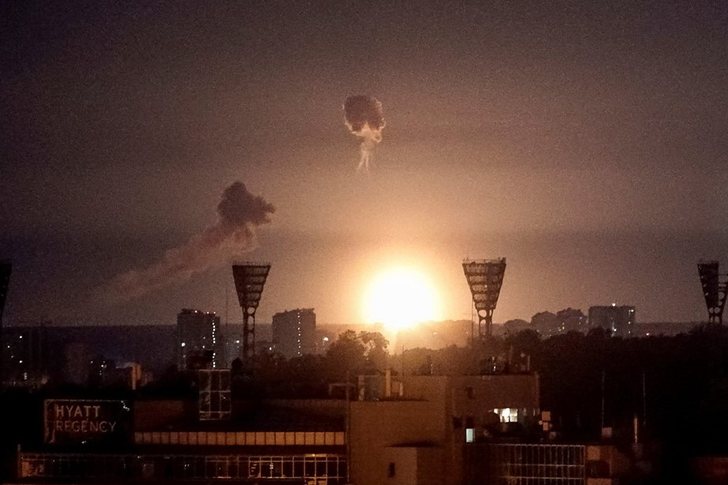
Ukraine has been hit by a massive Russian airstrike overni...

The United Arab Emirates (UAE) has denied reports that Isr...

US President Donald Trump and Xi Jinping held talks for tw...

A number of high-profile American business leaders, who ar...

While sitting at the center of a long table across from Tr...

US President Donald Trump has arrived at the Temple of Hea...

Bilateral talks between leaders Donald Trump and Xi Jinpin...

A photo shared for the 'X' platform by White House communi...

Israeli Prime Minister Benjamin Netanyahu secretly visited...

CNA has put under scanner the assets of Sokol Sadushi, the...

A 39-year-old citizen has been arrested in Lezha, after se...

CNA has launched another investigation that could lead to ...
Irfan Hysenbelliu is a businessman that we call "Irfan the...

The Special Board of Appeal (KPA) decided this Monday ...

The KPA vetting decided this Thursday to dismiss the p...

Suela Salavaçi, a prosecutor in the Prosecutor's Offic...

The Special Board of Appeal reinstated the prosecutor ...

Police have revealed details of the incident that occurred...
According to preliminary information, a person in his 60s ...

A triple accident occurred on the Peqin-Elbasan axis n...

The police have provided details regarding the accident th...

The public sector took the lead in absorbing the workforce...

Today, our country will be under the influence of unstable...

The Institute of Geosciences has today shared a forecast r...

Company leaders can improve productivity by investing in a...
Oil prices fell in early trading on Monday, falling furthe...
Although Albania does not have a developed industry on the...

North Korea is said to have achieved some impressive resul...

US Ambassador to the United Nations, Mike Waltz, said toda...

Two windows, a century of history and the metaphysics of p...

In my research at the Central State Archives, specifically...

At a time when industrial products are increasingly taking...

Trust among people is not just a three-syllable word. It c...

After strong savings growth in the years following the pan...

This Monday, one US dollar is bought for 81.5 lek and sold...

This Sunday, one US dollar is bought for 81.5 lek and sold...

This Saturday, one US dollar is bought for 81.7 lek and so...